File:STS068-239-90 - Image of Taipei Area.jpg
Contenuti della pagina non supportati in altre lingue.
Dâ Wikipedia, la nciclupidìa lìbbira.

Diminzioni di st'antiprima: 599 × 600 pixel. Àutri risuluzzioni: 240 × 240 pixel | 479 × 480 pixel | 767 × 768 pixel | 1 022 × 1 024 pixel | 2 045 × 2 048 pixel | 4 085 × 4 091 pixel.
Virsioni a àuta risuluzzioni (4 085 × 4 091 pixel, grannizza dû file: 13,38 MB, tipu MIME: image/jpeg)
Stu file veni di Wikimedia Commons e purrìa èssiri adupiratu di àutri pruggetti. Appressu veni ammustrata la discrizioni prisenti ntâ sò pàggina di discrizzioni.
Discrizzioni
| DiscrizzioniSTS068-239-90 - Image of Taipei Area.jpg |
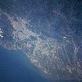
English: Located at the northern end of the island, Taipei (light colored area) is Taiwan capital and largest city (estimated 1997 population more than 2.6 million people). The Tanshui River (dark curving feature) flows through Taipei, eventually emptying into the Formosa Strait. Parallel runways (light-colored linear feature) of Chiang Kai Shek International Airport are visible west of Taipei near the coast. The Chungyang Mountains can be identified by the darker landscape, particularly in the lower right corner of the image. This mountain range extends northeast/southwest for the entire length of the island. The mountains tend to have steep slopes and are densely forested. The darker terrain along the west coast is vegetated hills, while the lighter colored terrain shows the distribution of urban areas and farmland. |
| Data | |
| Fonti | JSC Gateway to Astronaut Photography of Earth |
| Auturi | Earth Science and Remote Sensing Unit, Lyndon B. Johnson Space Center |
| Mission InfoField | STS068 |
| Roll InfoField | 239 |
| Frame InfoField | 90 |
| Geographic area InfoField | Taipei Area, Taiwan |
| Features InfoField | Taipei, river, mountains |
| Cloud percentage InfoField | 5% |
| Altitude InfoField | 118 nautical miles (219 km) |
| Look angle InfoField | 43° |
| Look direction InfoField | N |
| Sun Azimuth InfoField | 245° |
| Sun Elevation InfoField | 39° |
| Camera InfoField | Hasselblad |
| Film InfoField | 5046: Kodak, natural color positive, Lumiere 100/5046, ASA 100, standard base |
| Focal length InfoField | 250 mm |
| Luogo dello scatto | 23° 18′ N, 120° 48′ E | Posizione di questa e altre immagini su: OpenStreetMap |
|---|
| Posizione del soggetto | 25° 00′ N, 121° 30′ E | Posizione di questa e altre immagini su: OpenStreetMap |
|---|
Sta mmàggini o filmatu fu catalugatu dô Johnson Space Center dâ National Aeronautics and Space Administration (NASA) dê Stati Uniti dâ Mèricacô Photo ID: STS068-239-90.This tag does not indicate the copyright status of the attached work. A normal copyright tag is still required. See Commons:Licensing. Àutri lingui
العربية ∙ беларуская (тарашкевіца) ∙ български ∙ català ∙ čeština ∙ dansk ∙ Deutsch ∙ English ∙ español ∙ فارسی ∙ français ∙ galego ∙ magyar ∙ հայերեն ∙ Bahasa Indonesia ∙ italiano ∙ 日本語 ∙ македонски ∙ മലയാളം ∙ Nederlands ∙ polski ∙ português ∙ русский ∙ sicilianu ∙ slovenščina ∙ Türkçe ∙ українська ∙ 简体中文 ∙ 繁體中文 ∙ +/− |
Licenza
| Public domainPublic domainfalsefalse |
| Stu file è ntô duminiu pùbblicu pirchì criatu dâ NASA. La pulìtica supra lu copyright dâ NASA afferma ca «lu matiriali dâ NASA nun è prutiggiutu di copyright a menu ca nun sia spicificatu autrimenti». (NASA copyright policy e JPL Image Use Policy). |  | |
 |
Accura:
|
Didascalie
Aggiungi una brevissima spiegazione di ciò che questo file rappresenta
View of Taiwan taken by the crew of STS-68 in October 1994
STS-68 talianu
Valore sconosciuto senza un elemento Wikidata
tipo di file talianu
image/jpeg
coordinate del punto di vista talianu
23°18'N, 120°48'E
coordinate del luogo raffigurato talianu
25°0'N, 121°30'E
2 utt 1994
lunghezza focale talianu
250 millìmitru
sensibilità ISO talianu
100
checksum talianu
a6f95bd7907c0288a1118d0976dcf196eb751fab
dimensione dati talianu
14 032 330 byte
4 091 pixel
larghezza talianu
4 085 pixel
Cronoluggìa dû file
Fari clic supra un gruppu data/ura pi vìdiri lu file comu si prisintava ntô mumentu nnicatu.
| Data/Ura | Miniatura | Diminsioni | Utenti | Oggettu | |
|---|---|---|---|---|---|
| currenti | 13:18, 20 fri 2024 |  | 4 085 × 4 091 (13,38 MB) | Askeuhd | Improved quality and resolution |
| 09:32, 15 nuv 2004 |  | 639 × 640 (384 KB) | Wdshu | {{PD-USGov-NASA}} |
Pàggini c'ùsanu sta mmàggini
Li pàggini siquenti richiàmanu sta mmàggini:
