File:Geographic distribution of Bengali language.png

Contenuti della pagina non supportati in altre lingue.
Dâ Wikipedia, la nciclupidìa lìbbira.

Virsioni a àuta risuluzzioni(2 806 × 2 080 pixel, grannizza dû file: 1,36 MB, tipu MIME: image/png)

Stu file veni di Wikimedia Commons e purrìa èssiri adupiratu di àutri pruggetti. Appressu veni ammustrata la discrizioni prisenti ntâ sò pàggina di discrizzioni.

Discrizzioni

Discrizzioni
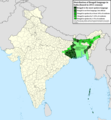
Ελληνικά: Γεωγραφική κατανομή της Βεγγαλικής Γλώσσας ανά επαρχία της Ινδίας και στο Μπανγκλαντές, τα χρώματα στις επαρχίες ποικίλουν ανάλογα με το ποσοστό ομιλητών (δεδομένα απογραφής 2011). Παράγωγο του αρχείου India district map (de-facto).svg.
English: Geographic distribution of Bengali language in India and Bangladesh. The map covers each district of India and the five shades of green show the percentage of Bengali language speakers in each district. Source: Indian census 2011. Feel free to enrich the map with data for more Indian districts, or fix any mistakes. Derivative of the file India district map (de-facto).svg.
Data
Fonti Òpira propia
Auturi NikosLikomitros

Licenza

Io, detentore del copyright su quest'opera, dichiaro di pubblicarla con la seguente licenza:
w:it:Creative Commons
attribbuzzioni sparti â stissa manera
Sî lìbbiru:
  • di cunnivìdiri – di cupiari, diffùnniri e trasmèttiri st'òpira
  • di canciari – d'adattari l'òpira
Sutta ê siguenti cunnizzioni:
  • attribbuzzioni – Hai a dari attribbuzzioni di l'òpira â manera spicificata dû sò auturi o dû titulari dâ licenza (pirò no a na manera chi pò fari pinzari chi iddi sustèninu o a tìa o lu tò utilizzu dâ sò òpira)
  • sparti â stissa manera – Si canci, trasformi, o sfrutti st'òpira comu puntu di partenza, poi diffùnniri l'òpira chi nni risurta sulamenti sutta â stissa licenza di chista o puru una sìmili.

Didascalie

Aggiungi una brevissima spiegazione di ciò che questo file rappresenta
Geographic distribution of Bengali language in India and Bangladesh. The map covers each district of India and the five shades of green show the percentage of Bengali language speakers in each district. Source: Indian census 2011.

Elementi ritratti in questo file

raffigura talianu

tipo di file talianu

image/png

Cronoluggìa dû file

Fari clic supra un gruppu data/ura pi vìdiri lu file comu si prisintava ntô mumentu nnicatu.

Data/UraMiniaturaDiminsioniUtentiOggettu
currenti17:05, 2 giugn 2022Miniatura di la virsioni dû 17:05, 2 giugn 20222 806 × 2 080 (1,36 MB)NikosLikomitrosA few districts of Arunachal Pradesh have a notable Bengali presence above of 1%, probably part of the Indian efforts to increase its presence in the region.
18:55, 1 giugn 2022Miniatura di la virsioni dû 18:55, 1 giugn 20222 806 × 2 080 (1,36 MB)NikosLikomitrosTwo extra fixes.
18:53, 1 giugn 2022Miniatura di la virsioni dû 18:53, 1 giugn 20222 806 × 2 080 (1,36 MB)NikosLikomitrosMinor fixes.
18:44, 1 giugn 2022Miniatura di la virsioni dû 18:44, 1 giugn 20222 806 × 2 080 (1,36 MB)NikosLikomitrosNow, this map covers all districts of India. Includes also extra information and a new colour key. The basemap is from Distribution_of_Jats_in_South_Asia.png.
23:09, 26 giu 2022Miniatura di la virsioni dû 23:09, 26 giu 20221 902 × 2 048 (1 002 KB)NikosLikomitrosUploaded own work with UploadWizard

Nudda pàggina cunteni sta mmàggini.

Utilizzu glubbali dû file

Puru li wiki appressu ùsanu stu file:

Metadati