Va ô cuntinutu

File:Europe map 1919.jpg

Contenuti della pagina non supportati in altre lingue.
Dâ Wikipedia, la nciclupidìa lìbbira.

Virsioni a àuta risuluzzioni (1 920 × 1 440 pixel, grannizza dû file: 1,41 MB, tipu MIME: image/jpeg)

Stu file veni di Wikimedia Commons e purrìa èssiri adupiratu di àutri pruggetti. Appressu veni ammustrata la discrizioni prisenti ntâ sò pàggina di discrizzioni.

Discrizzioni

Discrizzioni
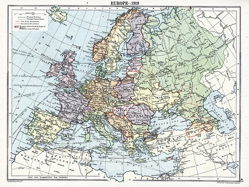
English: Map of en:Europe political divisions in 1919 (after the treaties of Brest-Litovsk and Versailles and before the treaties of Trianon, Riga, Kars and the establishment of en:Soviet Union and the republics of Ireland and Turkey) published by London Geographical Institute. This uploaded map is a photoshopped version of the original image located at hipkiss.org. According to the site, there are no copyrights to this map.
Fonti
Auturi
Àutri virsioni Derivative works of this file:  Europe map 1919 cropped.JPG
Maps of the history of Europe
BCE
aC

Weichselian ice age (c. 113,000–9700) · Neolithic expansion (c. 7000–4500) · Middle Neolithic (c. 4500–4000) · Late Neolithic (c. 4000–3000) · Copper Age – Corded Ware culture (c. 2900–2350) · Copper Age – Bellbeaker culture (c. 2800–1800) · Early Bronze Age – Unetice culture (c. 2300–1600) · Late Bronze Age – Urnfield culture (c. 1300—750) · Migrations (c. 1000–100) · Hallstatt & La Tène cultures (c. 800–100) · Roman Republic (510–40) · 220 · 218 · 200 · 201–100 · 58 · 49 · 39 · 30 BCE–6 CE


CE
dC

14 · 14–37 · 60 · 60 · 69 · 80 · Migrations 100–500 · 117 · 117 · 125 · Migrations 150–774 · Economy 180 · 271 · 293–305 · 337 · 395 · c. 395 · 400 · 400 · 450 · 457–61 · 476 · 480 · Franks 481–814 · Early Slavs 500–700 · 500 · 526 · 526–600 · Christianisation to 600 · c. 550 · 650 · Pontic Steppe 650 · 665 · 800 · Vikings 800–1050 · 814 · 843–70 · 850 · 900 · 912 · 998 · 1000 · 1000 · 1054 · 1092 · First Crusade 1095–99 · 1097 · 1135 · 1142 · 1147–49 · 1190 · 1190 · 1250 · c. 1250 · 1301-1400 · 1301-1400 · 1328 · 1345 · Black Plague 1347–51 · 1360 · 1400 · Trade routes c. 1400 · 1430 · 1470 · 1490 · 1492 · 1500 · 1519 · 1550 · 1560 · Religion 1560 · Religion 1600 · Religion 1618 · 1618–48 · 1648 · 1683 · 1700 · 1701 · 1708 · 1714 · 1721 · 1725–30 · 1739–1740 · 1740 · 1748–66 · 1783–1792 · 1787 · 1787 · 1789 · 1799 · 1812 · 1812 · 1812 · 1812 · 1813 · 1815 · 1815 · 1815 · 1818 · Ottoman Empire 1830–1923 · 1848–49 · 1861 · 1867 · 1871 · 1878 · 1890 · 1905 · 1911 · 1914 · 1914 · 1919 · 1919–29 · 1923 · 1929 · 1930 · 1940 · 1941–42 · 1942–45 · Cold War 1947–91 · 1950 · 1993–2006 · 2006 to date

(this template: · view · discuss )

Licenza

Public domain
Public domain
Stu file è ntô duminiu pùbblicu ntê Stati Uniti. Chistu s'àpplica a l'òpiri statunitenzi ca lu copyright scadìu, ô spissu pirchì la sò prima pubblicazzioni avvinni prima dô 1º di jinnaru 1929. Talìa sta pàggina pi chiossai spiegazzioni.

United States
United States
Sta mmàggini putissi nun èssiri ntô duminiu pùbblicu fora dê Stati Uniti, n particulari ntê Paisi e nta l'àrii ntê quali nun veni applicata la règula dâ durata chiù brevi pi l'òpiri statunitenzi, comu n Canada, Cina (nun a Hong Kong, Macau o Taiwan), Girmania, Mèssicu e Svìzzira. Lu criaturi e l'annu di pubblicazzioni sunnu nfurmazzioni essinziali e hannu a èssiri furnuti. Talìa Wikipedia:Public domain e Wikipedia:Copyright pi chiossai dittagghi.

Registro originale del caricamento

The original description page was here. All following user names refer to en.wikipedia.
  • 2007-11-03 20:09 MaGioZal 1996×1506×8 (1457003 bytes) Map of [[Europe]] political divisions in 1919 (after the treaties of [[Treaty_of_Brest-Litovsk|Brest-Livotsk]] and [[Treaty of Versailles|Versailles]] and before the [[Treaty of Riga]] and the creation of [[Soviet Union]]) published by London Geographical

Didascalie

Aggiungi una brevissima spiegazione di ciò che questo file rappresenta
The situation in Europe after WW1. Several new states were born such as Ukraine(the country in Yellow at the North of the Black Sea)

Elementi ritratti in questo file

raffigura talianu

tipo di file talianu

image/jpeg

Cronoluggìa dû file

Fari clic supra un gruppu data/ura pi vìdiri lu file comu si prisintava ntô mumentu nnicatu.

Data/UraMiniaturaDiminsioniUtentiOggettu
currenti06:41, 7 aus 2023Miniatura di la virsioni dû 06:41, 7 aus 20231 920 × 1 440 (1,41 MB)User-duckCropped to reduce border using CropTool with lossless mode.
00:29, 23 apr 2008Miniatura di la virsioni dû 00:29, 23 apr 20081 996 × 1 506 (1,39 MB)File Upload Bot (Magnus Manske) {{BotMoveToCommons|en.wikipedia}} {{Information |Description={{en|Map of en:Europe political divisions in 1919 (after the treaties of Brest-Livotsk and Versailles and before the treaties o

Nudda pàggina cunteni sta mmàggini.

Utilizzu glubbali dû file

Puru li wiki appressu ùsanu stu file:

Talìa l'utilizzu glubbali di stu file.