
File:British Isles.svg

Dimensioni di questa anteprima PNG per questo file SVG: 361 × 600 pixel. Àutri risuluzzioni: 144 × 240 pixel | 289 × 480 pixel | 462 × 768 pixel | 616 × 1 024 pixel | 1 232 × 2 048 pixel | 1 300 × 2 160 pixel.
Virsioni a àuta risuluzzioni (File SVG, diminzioni numinali 1 300 × 2 160 pixel, grannizza dû file: 154 KB)
Discrizzioni
| Discrizzioni |
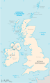
An SVG map of the British Isles, with the largest islands and archipelagos labelled. Always considered part of the British Isles
Sometimes considered part of the British Isles
Other lands |
| Fonti | Òpira propia |
| Auturi | Smurrayinchester |
| SVG sviluppo | Lu còdici surgenti di stu file SVG nun è vàlidu a càusa di 51 errura. Questa mappa in grafica vettoriale non valida secondo il W3C è stata creata con un programma SVG ignoto. This map is translated using SVG switch elements: all translations are stored in the same file. |
}
Licenza
Io, detentore del copyright su quest'opera, dichiaro di pubblicarla con la seguente licenza:

|
È cuncidutu lu pirmissu di cupiari, diffùnniri e/o canciari stu ducumentu sutta ê tèrmini dâ GNU Free Documentation License, la virsioni 1.2 o puru na virsioni succissivamenti pubblicata dâ Free Software Foundation; senza Sizzioni Nun mmutàbbili, senza Testi di Prima di Cupirtina, e senza Testi di Quarta di Cupirtina. Na copia dâ licenza s'attrova ntâ sizzioni ntitulata GNU Free Documentation License. |
| Stu file è suttapostu â licenza Creative Commons Attribution-Share Alike 3.0 Unported. | ||
| ||
| Questo tag di copyright è stato aggiunto nell'ambito dell'aggiornamento della licenza dei progetti Wikimedia. |
Derivative works
-
 македонски
 -
 Flag map (1801–1922)


derivative works
Derivative works of this file: British Isles mk.svg
Cronoluggìa dû file
Fari clic supra un gruppu data/ura pi vìdiri lu file comu si prisintava ntô mumentu nnicatu.
| Data/Ura | Miniatura | Diminsioni | Utenti | Oggettu | |
|---|---|---|---|---|---|
| currenti | 17:33, 10 fri 2019 | | 1 300 × 2 160 (154 KB) | MSG17 | Uploaded from SVG Translate. |
| 16:56, 13 utt 2018 |  | 1 300 × 2 160 (141 KB) | Seb35 | small bug: translations have to be before the default text else the PNG rendering selects the default text | |
| 16:51, 13 utt 2018 |  | 1 300 × 2 160 (141 KB) | Seb35 | added French translation | |
| 16:50, 20 maiu 2014 |  | 1 300 × 2 160 (135 KB) | NikNaks | More cleaning. File could still be a lot smaller than it currently is | |
| 05:02, 20 maiu 2014 |  | 1 300 × 2 160 (152 KB) | NikNaks | Malay translation | |
| 04:36, 20 maiu 2014 |  | 1 300 × 2 160 (148 KB) | NikNaks | Cleaning unfortunately lost detail. Will have to return to later | |
| 04:22, 20 maiu 2014 |  | 1 297 × 2 160 (37 KB) | NikNaks | Attempting to clean up the file before translation | |
| 14:37, 20 aus 2006 |  | 1 297 × 2 160 (196 KB) | Smurrayinchester | An SVG map of the British Isles, with the largest islands and archipelagos labeled. {{legend|#fff0de|Always considered part of the British Isles|border=#ffffff}} {{legend|#ffb380|Sometimes considered part of the British Isles|border=#ffffff}} {{legend|#e |
Pàggini c'ùsanu sta mmàggini
Li pàggini siquenti richiàmanu sta mmàggini:
Utilizzu glubbali dû file
Puru li wiki appressu ùsanu stu file:
- Utilizzu supra ar.wikipedia.org
- Utilizzu supra az.wikipedia.org
- Utilizzu supra be.wikipedia.org
- Utilizzu supra bs.wikipedia.org
- Utilizzu supra ceb.wikipedia.org
- Utilizzu supra ckb.wikipedia.org
- Utilizzu supra da.wikipedia.org
- Utilizzu supra en.wikipedia.org
- Geography of the Isle of Man
- Burhou
- Talk:International Football Association Board
- Module:Location map/data/British Isles/doc
- List of offshore wind farms in the Irish Sea
- Siege of St Andrews Castle
- User:Malpass93/sandbox
- Module:Location map/data/British Isles
- 2014 Senior Open Championship
- 2017 Senior Open Championship
- 2018 Eisenhower Trophy
- User:Grover cleveland/History of the laws of the game/List of IFAB meetings
- User:Grover cleveland/English managers
- 2018 Espirito Santo Trophy
- 1965 European Amateur Team Championship
- 1975 European Amateur Team Championship
- 1981 European Amateur Team Championship
- 1989 European Amateur Team Championship
- 1997 European Amateur Team Championship
- 2005 European Amateur Team Championship
- 2007 European Amateur Team Championship
- 2009 European Amateur Team Championship
- 1971 European Ladies' Team Championship
- 1979 European Ladies' Team Championship
- 1987 European Ladies' Team Championship
- 1991 European Ladies' Team Championship
- 2013 European Ladies' Team Championship
- 2021 European Ladies' Team Championship
- 2022 European Amateur Team Championship
- 2022 European Ladies' Team Championship
- 2013 Senior Open Championship
- 2012 Senior Open Championship
- 2011 Senior Open Championship
- 2008 Senior Open Championship
- 2006 Senior Open Championship
- 2002 Senior British Open
- 2001 Senior British Open
- 2000 Senior British Open
- 2022 Senior Open Championship
- User:Erik Sergeant/sandbox 2
- 2023 Senior Open Championship
- Module:Location map/data/British Isles/sandbox
- Draft:2024 Monoposto Championship
Talìa l'utilizzu glubbali di stu file.