
File:Rio de la Plata BA 2.JPG

Diminzioni di st'antiprima: 800 × 530 pixel. Àutri risuluzzioni: 320 × 212 pixel | 640 × 424 pixel | 1 024 × 678 pixel | 1 280 × 848 pixel | 3 032 × 2 008 pixel.
Virsioni a àuta risuluzzioni (3 032 × 2 008 pixel, grannizza dû file: 1,75 MB, tipu MIME: image/jpeg)
Discrizzioni
| Discrizzioni |
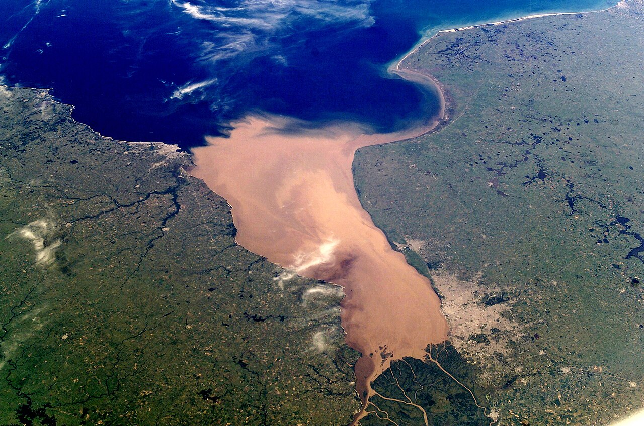
English: NASA astronaut photograph of the Río de la Plata estuary looking west-east, the picture does not show a north and south view. Actually the right is the south and the bottom of the picture is the west. Note Greater Buenos Aires on the right side of the picture, and Montevideo on the left side (near the mouth of the Santa Lucía. To the east of Greater Buenos Aires, a smaller conurbation is visible, including La Plata (a few kilometers inland) and the Berisso-Ensenada area (near the river). Water on the river is brown because of sediments carried from the Paraná and Uruguay rivers. The color turns blue when approaching the South Atlantic Ocean. The exact location of the color change (which also implies a change from fresh to salt water) depends on winds and currents.
Español: Foto del Río de la Plata tomada desde satélite, la cámara apunta hacia el sudeste. Se aprecia la desembocadura del río Río Uruguay y del Río Paraná. En la margen derecha destaca Buenos Aires y también la ciudad de La Plata; en la izquierda, se aprecia Montevideo, próximo a la desembocadura del Río Santa Lucía. En esta zona se observa cambio de color en el agua, la cual se torna más salada según se aproxima al Océano Atlántico. |
| Data | |
| Fonti | eol.jsc.nasa.gov: [1] |
| Auturi | Earth Sciences and Image Analysis Laboratory, NASA Johnson Space Center |
Licenza
| Stu file è ntô duminiu pùbblicu pirchì criatu dâ NASA. La pulìtica supra lu copyright dâ NASA afferma ca «lu matiriali dâ NASA nun è prutiggiutu di copyright a menu ca nun sia spicificatu autrimenti». (NASA copyright policy e JPL Image Use Policy). | ||
 |
Accura:
|
Sta mmàggini o filmatu fu catalugatu di unu dê centri dâ National Aeronautics and Space Administration (NASA) dê Stati Uniti dâ Mèricacô Photo ID: ISS006-E-38952.This tag does not indicate the copyright status of the attached work. A normal copyright tag is still required. See Commons:Licensing. Àutri lingui
|
|
| Annutazzioni | Sta mmàggini è annutata: Talìa l'annutazzioni nta Commons |
Cronoluggìa dû file
Fari clic supra un gruppu data/ura pi vìdiri lu file comu si prisintava ntô mumentu nnicatu.
| Data/Ura | Miniatura | Diminsioni | Utenti | Oggettu | |
|---|---|---|---|---|---|
| currenti | 12:12, 26 fri 2013 | | 3 032 × 2 008 (1,75 MB) | Denniss | Reverted to version as of 03:52, 9 November 2011 |
| 05:52, 9 nuv 2011 |  | 3 032 × 2 008 (1,75 MB) | Creysmon07 | Corrected the contrast to more realistic. | |
| 11:51, 4 maiu 2009 |  | 3 032 × 2 008 (1,37 MB) | Monfornot | removed bottom border, improved contrast a bit | |
| 23:14, 7 aus 2005 |  | 3 032 × 2 064 (866 KB) | ALE! | Larger version. Colours not so exagerated; more natural | |
| 05:18, 29 nuv 2004 |  | 612 × 424 (37 KB) | Tano4595 | Río de la Plata |
Pàggini c'ùsanu sta mmàggini
Li pàggini siquenti richiàmanu sta mmàggini:
Utilizzu glubbali dû file
Puru li wiki appressu ùsanu stu file:
- Utilizzu supra af.wikipedia.org
- Utilizzu supra ar.wikipedia.org
- Utilizzu supra ast.wikipedia.org
- Utilizzu supra azb.wikipedia.org
- Utilizzu supra be-tarask.wikipedia.org
- Utilizzu supra be.wikipedia.org
- Utilizzu supra bg.wikipedia.org
- Utilizzu supra bh.wikipedia.org
- Utilizzu supra bn.wikibooks.org
- Utilizzu supra br.wikipedia.org
- Utilizzu supra bs.wikipedia.org
- Utilizzu supra ca.wikipedia.org
- Utilizzu supra cs.wikipedia.org
- Utilizzu supra da.wikipedia.org
- Utilizzu supra de.wikipedia.org
- Utilizzu supra en.wikipedia.org
- Utilizzu supra en.wikibooks.org
- Utilizzu supra en.wiktionary.org
- Utilizzu supra eo.wikipedia.org
- Utilizzu supra es.wikipedia.org
Talìa l'utilizzu glubbali di stu file.