File:Europe map 1648.PNG
Contenuti della pagina non supportati in altre lingue.
Dâ Wikipedia, la nciclupidìa lìbbira.

Virsioni a àuta risuluzzioni(1 894 × 1 367 pixel, grannizza dû file: 195 KB, tipu MIME: image/png)

Stu file veni di Wikimedia Commons e purrìa èssiri adupiratu di àutri pruggetti. Appressu veni ammustrata la discrizioni prisenti ntâ sò pàggina di discrizzioni.

Sta mmàggini (catigurizzazzioni autumàtica: historical map) o tutti li mmàggini nta sta catigurìa o gallarìa avìssiru a èssiri ricriati usannu gràfica vitturiali comu file SVG. Chistu offri diversi vantaggi: talìa Commons:Media for cleanup pi chiossai nfurmazzioni. Si è dispunìbbili na virsioni n furmatu SVG di sta mmàggini, pi favuri carricala. Doppu aviri carricatu un file SVG, sustituisci st'avvisu cô template {{Vector version available|nomu_mmàggini.svg}}.

Discrizzioni

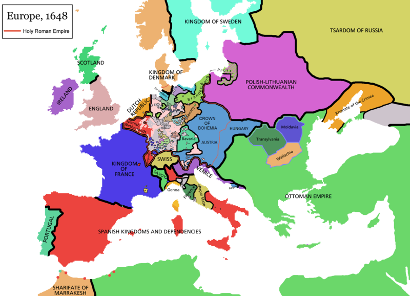
Map of Europe in 1648 (at the end of the Thirty Years War), based on free map of europe Image:BlankMap-Europe.png. Red line marks the border of the Holy Roman Empire. Information from Penguin atlas of modern history. (what year?)

Maps of the history of Europe
BCE
aC

Weichselian ice age (c. 113,000–9700) · Neolithic expansion (c. 7000–4500) · Middle Neolithic (c. 4500–4000) · Late Neolithic (c. 4000–3000) · Copper Age – Corded Ware culture (c. 2900–2350) · Copper Age – Bellbeaker culture (c. 2800–1800) · Early Bronze Age – Unetice culture (c. 2300–1600) · Late Bronze Age – Urnfield culture (c. 1300—750) · Migrations (c. 1000–100) · Hallstatt & La Tène cultures (c. 800–100) · Roman Republic (510–40) · 220 · 218 · 200 · 201–100 · 58 · 49 · 39 · 30 BCE–6 CE


CE
dC

14 · 14–37 · 60 · 60 · 69 · 80 · Migrations 100–500 · 117 · 117 · 125 · Migrations 150–774 · Economy 180 · 271 · 293–305 · 337 · 395 · c. 395 · 400 · 400 · 450 · 457–61 · 476 · 480 · Franks 481–814 · Early Slavs 500–700 · 500 · 526 · 526–600 · Christianisation to 600 · c. 550 · 650 · Pontic Steppe 650 · 665 · 800 · Vikings 800–1050 · 814 · 843–70 · 850 · 900 · 912 · 998 · 1000 · 1000 · 1054 · 1092 · First Crusade 1095–99 · 1097 · 1135 · 1142 · 1147–49 · 1190 · 1190 · 1250 · c. 1250 · 1301-1400 · 1301-1400 · 1328 · 1345 · Black Plague 1347–51 · 1360 · 1400 · Trade routes c. 1400 · 1430 · 1470 · 1490 · 1492 · 1500 · 1519 · 1550 · 1560 · Religion 1560 · Religion 1600 · Religion 1618 · 1618–48 · 1648 · 1683 · 1700 · 1701 · 1708 · 1714 · 1721 · 1725–30 · 1739–1740 · 1740 · 1748–66 · 1783–1792 · 1787 · 1787 · 1789 · 1799 · 1812 · 1812 · 1812 · 1812 · 1813 · 1815 · 1815 · 1815 · 1818 · Ottoman Empire 1830–1923 · 1848–49 · 1861 · 1867 · 1871 · 1878 · 1890 · 1905 · 1911 · 1914 · 1914 · 1919 · 1919–29 · 1923 · 1929 · 1930 · 1940 · 1941–42 · 1942–45 · Cold War 1947–91 · 1950 · 1993–2006 · 2006 to date

(this template: · view · discuss )


Licenza

GNU head È cuncidutu lu pirmissu di cupiari, diffùnniri e/o canciari stu ducumentu sutta ê tèrmini dâ GNU Free Documentation License, la virsioni 1.2 o puru na virsioni succissivamenti pubblicata dâ Free Software Foundation; senza Sizzioni Nun mmutàbbili, senza Testi di Prima di Cupirtina, e senza Testi di Quarta di Cupirtina. Na copia dâ licenza s'attrova ntâ sizzioni ntitulata GNU Free Documentation License.
w:it:Creative Commons
attribbuzzioni sparti â stissa manera
Stu file è suttapostu â licenza Creative Commons Attribution-Share Alike 3.0 Unported.
Sî lìbbiru:
  • di cunnivìdiri – di cupiari, diffùnniri e trasmèttiri st'òpira
  • di canciari – d'adattari l'òpira
Sutta ê siguenti cunnizzioni:
  • attribbuzzioni – Hai a dari attribbuzzioni di l'òpira â manera spicificata dû sò auturi o dû titulari dâ licenza (pirò no a na manera chi pò fari pinzari chi iddi sustèninu o a tìa o lu tò utilizzu dâ sò òpira)
  • sparti â stissa manera – Si canci, trasformi, o sfrutti st'òpira comu puntu di partenza, poi diffùnniri l'òpira chi nni risurta sulamenti sutta â stissa licenza di chista o puru una sìmili.
Questo tag di copyright è stato aggiunto nell'ambito dell'aggiornamento della licenza dei progetti Wikimedia.

derivative works

Derivative works of this file:

Didascalie

Aggiungi una brevissima spiegazione di ciò che questo file rappresenta

Elementi ritratti in questo file

raffigura talianu

tipo di file talianu

image/png

Cronoluggìa dû file

Fari clic supra un gruppu data/ura pi vìdiri lu file comu si prisintava ntô mumentu nnicatu.

(Ùrtima | Prima) Talìa (10 cchiù novi) () (10 | 20 | 50 | 100 | 250 | 500).
Data/UraMiniaturaDiminsioniUtentiOggettu
currenti11:44, 14 apr 2021Miniatura di la virsioni dû 11:44, 14 apr 20211 894 × 1 367 (195 KB)TenanReverted to version as of 16:09, 12 October 2017 (UTC) See discussion
12:47, 9 mar 2021Miniatura di la virsioni dû 12:47, 9 mar 20211 894 × 1 367 (210 KB)TTBCamhReverted to version as of 17:18, 20 September 2018 (UTC). I don't know why Raderich is saying this is an arbitrary change—Catalonia was under the possession of the French king in 1648, following the Catalan Revolt of 1640. This map is correct and the previous one is incorrect.
14:12, 25 sit 2018Miniatura di la virsioni dû 14:12, 25 sit 20181 894 × 1 367 (195 KB)RaderichReverted to version as of 21:15, 18 September 2018 (UTC) Undone arbitrary changes. Revert to correct map as uploaded by its creator Roke~commonswiki
19:18, 20 sit 2018Miniatura di la virsioni dû 19:18, 20 sit 20181 894 × 1 367 (210 KB)AmbroiseLThe Catalan counties were French since they proclaimed Louis XIV of France as their king. They wanted to be French in order not to obey the king of Spain anymore. Courland was a quite free vassal state of Poland. The reverted version doesn't show it. The reverted version also doesn't show the Venetian islands in the Adriatic Sea, and the Algerian towns that France occupied. Hence, I re-revert to the more precise version.
23:15, 18 sit 2018Miniatura di la virsioni dû 23:15, 18 sit 20181 894 × 1 367 (195 KB)RaderichReverted to version as of 16:09, 12 October 2017 (UTC)
12:45, 19 giugn 2018Miniatura di la virsioni dû 12:45, 19 giugn 20181 894 × 1 367 (210 KB)AmbroiseLReverted to version as of 12:06, 20 January 2017 (UTC) — reverted to the version with fixed names, my mistake
12:37, 19 giugn 2018Miniatura di la virsioni dû 12:37, 19 giugn 20181 894 × 1 367 (150 KB)AmbroiseLReverted to version as of 10:33, 24 September 2016 (UTC)
18:09, 12 utt 2017Miniatura di la virsioni dû 18:09, 12 utt 20171 894 × 1 367 (195 KB)Reverted to version as of 12:42, 9 September 2016 (UTC) why is Catalonia French? Not shown as such on File:Europe_1648_westphal_1884.jpg
14:06, 20 jin 2017Miniatura di la virsioni dû 14:06, 20 jin 20171 894 × 1 367 (210 KB)FakirbakirNames of Austria, Bohemia and Hungary are fixed.
12:33, 24 sit 2016Miniatura di la virsioni dû 12:33, 24 sit 20161 894 × 1 367 (150 KB)AmbroiseLAdjunction of polish-lithuanian vassal state of Courland
(Ùrtima | Prima) Talìa (10 cchiù novi) () (10 | 20 | 50 | 100 | 250 | 500).

Li pàggini siquenti richiàmanu sta mmàggini:

Utilizzu glubbali dû file

Puru li wiki appressu ùsanu stu file:

Talìa l'utilizzu glubbali di stu file.

Metadati